
environmental SCIENTIST | Talking tactics: Environmental protection and armed conflicts | June 2020
Doug Weir examines how citizen science could help to protect both people and ecosystems in conflict zones.
Armed conflicts can create acute environmental risks and lead to degradation that impacts ecosystems, human health and livelihoods. However, poor security conditions in conflict-impacted areas have historically hampered on-the-ground investigations into the environmental legacy of conflicts. In turn this has encouraged the use of remote sensing and open-source intelligence (data and information that is available to the general public) for documenting environmental harm, although without data from the ground these approaches have their limitations. The peacetime use of low-cost participatory scientific research – citizen science – has grown rapidly in recent years, and researchers are now exploring its potential applications in areas affected by conflicts.1
Assessing war's environmental legacy
Efforts to quantify the environmental consequences of armed conflicts date back to the Vietnam War.2 Until the conflicts in the Former Yugoslavia, assessments had largely been undertaken by academia and civil society. The bombing of petrochemical sites and use of depleted uranium weapons in the conflicts in the Balkans changed this, and led to the emergence of a model of post-conflict environmental assessments from the United Nations Environment Programme (UNEP).3 Over the last two decades, this model has been applied to numerous conflicts and to a wide range of environmental problems, from serious pollution incidents to damage to natural resources.
Although these assessments have vastly increased our understanding of the environmental consequences of conflicts, they have their limitations. By definition they are undertaken after conflicts, and typically when security conditions allow access for UN experts. They also tend to focus on the areas of highest concern, are often biased towards specific events rather than long-term changes, and any follow-up work on the problems they identify is left to the affected state, whose capacity and attention may be elsewhere.
It is no coincidence that growing interest in the environmental dimensions of armed conflicts – and their consequences for people – have developed alongside rapid increases in the availability of data on the environmental and societal conditions in conflict-affected areas. Coupling data derived from satellites and social media with online documentation from a diverse range of sources has allowed non-governmental organisations (NGOs) and others to document and draw attention to environmentally damaging incidents during conflicts, sometimes in near-real time.
This marks an astonishing change in the visibility of environmental harm during conflicts, and one that is already contributing to the development of law and policy intended to reduce harm.4 However, remotely accessible datasets can be limited, especially where robust ground verification and supplementation are required to inform the scale of damage and risks to people or ecosystems. This ground perspective is also critical for targeting humanitarian and environmental assistance, and for informing remediation and post-conflict recovery. Moreover, it can hold open the prospect of ensuring accountability for harm – a goal that is poorly served by the existing legal frameworks protecting the environment in relation to armed conflicts.
The civilian as citizen scientist
The idea that only professional researchers can collect environmental information is a fairly recent notion – members of the public and enthusiastic amateurs have actually been performing this function since at least the 18th century.5 The term ‘citizen science’ was coined in 1995 and since then has come to describe a rapidly expanding field of activities, from large-scale information gathering to social justice activism, enabled by the internet and low-cost sensing technologies. As the field has grown and professionalised, its value has been accepted by governments and it has repeatedly played an important role in supporting, and at times challenging, the work of national regulatory authorities.
Underpinned by openness, sharing and the participation of communities across the entire scientific process, citizen science projects have the potential to inform, educate and empower participants. They can also benefit researchers. The local, situated knowledge of project participants can help refine methodologies and interpret results, and large projects, particularly those backed by mobile phone apps or websites, can provide far more observations than individual professional researchers can gather alone.6
On the face of it, these attributes hold promise for research projects that aim to plug the geographical and temporal gap inherent in the post-conflict assessments undertaken by the international community. They could also complement and reinforce data gathered by remote sensing and open-source methods. But is it feasible or realistic to expect civilians to be citizen scientists in participatory environmental research? Communities affected by conflict, whether in situ or following displacement, face priorities that may be far removed from environmental concerns, but that is not always the case.
A growing number of examples support the idea that participatory data collection can be undertaken in insecure contexts. In eastern Ukraine, the Redonbass platform, set up by the UN Development Programme (UNDP), collated geotagged photos of damage to buildings taken by residents in order to document the harm caused by explosive weapons and to expedite repairs.7 In the rainforests of Cameroon, the Zoological Society of London (ZSL) has worked with the Baka people on the participatory mapping and reporting of illegal poaching.8 World Cleanup Day’s online platform allows app users to geotag the locations of solid waste for removal and has users in several conflict-affected and insecure areas.9 Meanwhile, a project led by the University of Bath’s Department of Chemical Engineering developed and deployed a low-cost, portable and user-friendly multi-sensing device for detecting heavy metals and measuring physicochemical parameters in water sources in Colombia (see Figure 1).10 One of the motivations for the project was the high levels of mercury pollution in rivers from artisanal gold mining, which has played an important role in the ongoing insecurity in areas of the country.
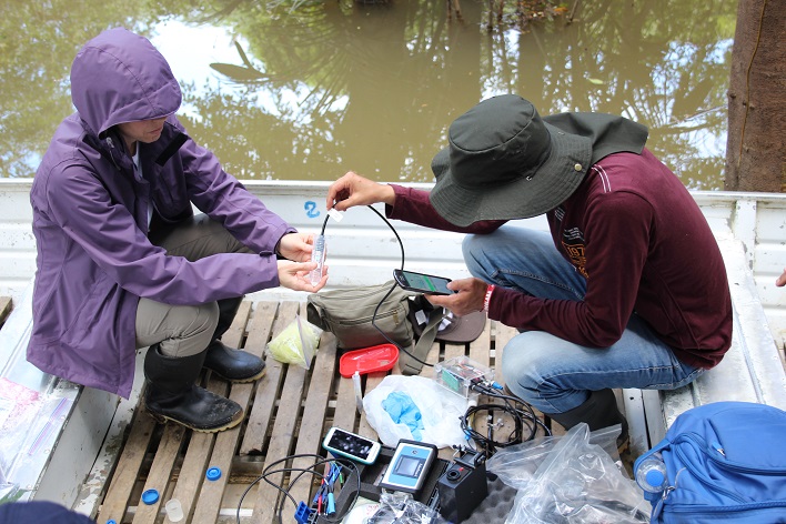 |
| Figure 1. A multi-sensing device for testing water sources enables communities in Colombia to determine if the water is safe for them to use, whilst also mapping the areas of water affected by illegal mining activity, an important factor in the ongoing insecurity in areas of the country.10 (© Mirella Di Lorenzo) |
Just-good-enough data that has an impact
A long-standing objection to the use of citizen science has been over the quality of data. It is inescapable that low-cost sensors will never be able to match the accuracy of contemporary research-grade instrumentation, although the gap may be shrinking thanks to super-materials and artificial intelligence. But this misses the point. Not only is the data itself just one component of projects – alongside community engagement and empowerment – but it is intended to complement, rather than replace, official monitoring. In earlier years the field viewed its goal as the collection of data that was just good enough: just good enough to highlight an issue, to trigger a response from the authorities or to stimulate more in-depth studies. In the case of the constraints found in post-conflict spaces, “just good enough” might mean drawing attention to a problem or providing stop-gap monitoring until the authorities can replace capacity lost due to conflict, or develop more long-term solutions.
Field access is another barrier for projects in insecure settings. Yet civil-society actors are often present in these spaces. Local NGOs, and international humanitarian or mine-action actors could provide the route into the field for equipment, provide capacity-building support for communities and help support projects aimed at improving environmental cooperation as a tool for peacebuilding.
The final challenge lies in how best to use the data; its ownership and decisions about how to use it must ultimately rest with the participating communities, who will have been involved in the study design from the outset. This will depend on the objective of particular studies. At its simplest, data could be used locally, for example in risk-awareness programmes in connection to pollution hazards, or for advocacy. The openness and transparency that is the hallmark of these kinds of studies could also help to counter growing trends in the weaponisation of environmental information during and after conflicts.11
Looking beyond the local, the data architecture necessary to ensure that results can reach those with the ability to act on it also exists. For example, the UN Office for the Coordination of Humanitarian Affairs’ Humanitarian Data Exchange collects data from more than 1,000 organisations,12 which is subsequently fed into the UN’s humanitarian response system. In a sign of things to come, there is also growing international interest in developing a Digital Ecosystem for the Planet, a home for environmental data gathered by remote sensing and many other methods, including citizen science.13
Given the breadth of environmental harms associated with armed conflicts, and the paucity of field data on them, there is no shortage of potential applications for civilian science studies. Oil pollution is a common feature of many conflicts due to attacks on infrastructure, governance failures, or environmentally problematic civilian coping strategies.14 Land degradation is also common, as is habitat and biodiversity loss, due to overharvesting, disruption to land management systems and the availability of firearms. The growth in warfare in urban areas has made damage to water and sanitation infrastructure commonplace, and this damage generates air quality issues linked to pulverised building materials and rubble – problems that are as yet uncharacterised in the literature. Participatory research could help to shed light on the human and environmental consequences of all these forms of harm and it is something that we are working on at the Conflict and Environment Observatory, together with colleagues from civil society and academia.
Fundamental environmental human rights
Armed conflicts have been likened to sustainable development in reverse. While the specific environmental cost of each conflict varies depending on how and where it is fought, and on who is involved, in the majority of cases we see threats to public health and ecosystems, and damage that impedes recovery. In spite of this, the environment struggles for attention in these contexts, with obvious implications.
Addressing this requires creative thinking and approaches tailored for the specific needs of communities and the challenging circumstances they find themselves in. The rapid expansion of citizen science in peacetime, and its gradual progress into insecure or politicised settings, means that there is a wealth of experience and best practice to build on. Moreover, viewing the civilian as a citizen scientist in projects that help to protect and empower communities serves as a timely reminder that fundamental environmental human rights continue to apply during conflicts and in their wake.
Doug Weir has undertaken research and advocacy on the environmental legacy of armed conflicts and military activities since 2005 and is the Research and Policy Director at the Conflict and Environment Observatory. He is also a Visiting Research Fellow at the Marjan Centre for the Study of War and the Non-Human Sphere at King’s College London.
contact@ceobs.org | @detoxconflict | www.ceobs.org
References
- Weir, D., McQuillan, D. and Francis, R.A. (2019) Civilian science: the potential of participatory environmental monitoring in areas affected by armed conflicts. Environmental Monitoring and Assessment, 191, 618. https://doi.org/10.1007/s10661-019-7773-9 (Accessed: 22 June 2020).
- Littauer, R. and Uphoff, N.T. (1972) The Air War in Indochina. Rev. edn. New York, NY: Cornell University.
- Jensen, D. and Lonergan, S. (2012) Natural resources and post-conflict assessment, remediation, restoration, and reconstruction: lessons and emerging issues, in Jensen, D. and Lonergan, S. (eds.) Assessing and Restoring Natural Resources in Post-Conflict Peacebuilding. London: Earthscan, pp. 411–461.
- Weir, D. (2017) Reframing the remnants of war: the role of the International Law Commission, governments, and civil society, in Stahn, C., Iverson, J. and Easterday, J.S. (eds.) Environmental Protection and Transitions from Conflict to Peace: Clarifying Norms, Principles, and Practices. Oxford Scholarship Online, https://www.oxfordscholarship.com/view/10.1093/oso/9780198784630.001.0001/oso-9780198784630 (Accessed: 28 April 2020).
- Resnik, D.B., Elliott, K.C. and Miller, A.K. (2015) A framework for addressing ethical issues in citizen science. Environmental Science and Policy, 54, pp. 475–481.
- iNaturalist (no date) www.inaturalist.org (Accessed: 28 April 2020).
- Ukraine Digital News (2015) Destructions in Donbass highlighted by two online platforms. https://www.uadn.net/2015/01/27/destructions-in-donbass-highlighted-by-two-online-platforms/ (Accessed: 28 April 2020).
- Hoyte, S. (2016) Forest peoples, cow skin soup, and extreme citizen science. Hunt and Gather, https://simonhoyte.wordpress.com/2016/10/10/forest-peoples-cow-skin-soup-and-extreme-citizen-science (Accessed: 12 March 2020).
- World Cleanup Day (no date) Mapping for a clean planet. https://www.worldcleanupday.org/map-it (Accessed: 28 April 2020).
- University of Bath (2018) New device to protect communities in Colombia from unsafe water. Phys.org, https://phys.org/news/2018-06-device-colombia-unsafe.html (Accessed: 12 March 2020).
- Weir, D. and Denisov, N. (2019) The weaponisation of environmental information in the era of fake news. Conflict and Environment Observatory, https://ceobs.org/the-weaponisation-of-environmental-information-in-the-era-of-fake-news (Accessed: 12 March 2020).
- The Humanitarian Data Exchange. https://data.humdata.org (Accessed: 28 April 2020).
- Jensen, D. Bakker, K. and Reimer, C. (2020) Annex 1: priorities and processes in 2020 for a Digital Ecosystem for the Planet. Medium, https://medium.com/@davidedjensen_99356/annex-processes-and-priorities-in-2020-for-a-digital-ecosystem-884b09cb8cc7 (Accessed: 12 March 2020).
- Zwijnenburg, W. (2016) Scorched earth and charred lives. PAX. http://www.paxforpeace.nl/publications/all-publications/scorched-earth-and-charred-lives (Accessed: 22 June 2020).
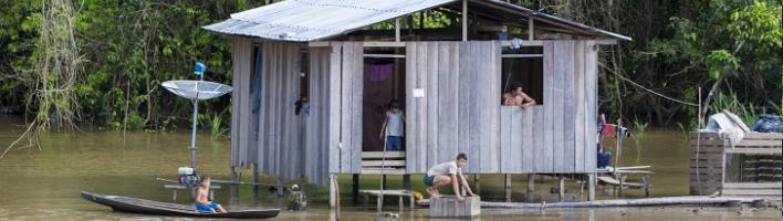
Banner image source: © Michel Uyttebroeck Piccaya sprl | Adobe Stock